2nd Hand Equipment - Coming soon!

We are now putting the final touches to the World Mining Equipment 2nd Hand market place. If you would like information on this service contact


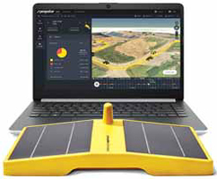
Propeller Aerobotics announced a beta program for DirtMate, described by the company as a machine tracking system that delivers survey-grade progress and productivity data whenever needed. DirtMate sensors fi ll in blind spots that occur between surveys with real-time data. After a wireless installation, the solar- powered sensors collect RTK GPS and IMU information. The sensors can also be wired to the machine.
The data stream feeds the Propeller Platform, which converts the data into live 3D surfaces. Worksites can use this information to generate cut and fill heat maps, utilization graphs, and progress-to-design measurements, Propeller reported.
More information : http://www.propelleraero.com